Canada’s oldest weekly newspaper
© 2026 The Picton Gazette
Since 1830

 Grant Hopkins. (Jason Parks/Gazette Staff)
The municipality could be getting more out of its modest Geographic Information System (GIS) program.
That is the consultants’ assessment of the County’s GIS technology. Melissa Dick and Kathy MacMillan of Esri Canada told Council last week that the County needs a geospatial strategy and a governance framework for its GIS program.
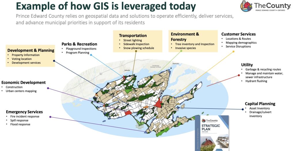
GIS is a computer-based framework that gathers, manages, analyzes, and maps all types of data by connecting it to a specific geographic location or GPS point.
Layer upon layer of information—including maps, satellite imagery, and 3D scenes—help planners to understand spatial patterns, relationships, and context. The County uses GIS for myriad functions, from planning and zoning notations to infrastructure monitoring, maintenance, and environmental uses. It maintains a tree inventory and inspection map and uses GIS to track invasive species.
It maps almost all of its water infrastructure, including the size, type and general conditions of pipes and sewers.
GIS is no longer a simple computer program running in the background at the Planning department, a cache of roll numbers and zoning. It is now a vital tool that assists virtually every municipal department and informs critical decisions on everything from infrastructure to recreation and operations.
A geospatial governance framework will clarify roles, responsibilities, and procedures, guide project prioritization, and define GIS services to help staff understand what to expect from the GIS team and their own involvement in geospatial initiatives.
The absence of such a framework means inefficiencies and reactive operations, hindering the ability to meet growing demands.
“Developing a strategic plan would provide a clear roadmap for prioritizing investments and improving coordination,” Ms. Dick said.
Esri’s Location Intelligence (Li360) Assessment compared the County to a number of Canadian municipalities in categories including strategy, technology and literacy. The County is firmly in the “developing” stage, but would make significant strides if it could align and better integrate geospatial strategy within its long-term planning exercises.
Grant Hopkins is the County’s GIS Program Supervisor. Over the past decade, GIS has quietly supported almost every part of the County’s operations, from planning, engineering, environmental services, emergency response, revenue, and customer service to frontline field work.
The demands on the County’s small GIS team have grown steadily and significantly.
Mr. Hopkins said his team has reached a point where it continually responds to immediate needs, with limited capacity to plan ahead, modernize tools, or support emerging opportunities.
“It is increasingly difficult to keep up with requests, explore new capabilities, or introduce efficiencies that many departments are asking for. This is not due to lack of commitment or skill. Assessments repeatedly describe the GIS team as “small but mighty,” capable and collaborative, with a strong reputation across departments.”
Mr. Hopkins noted improving operations will require consideration in the 2027 municipal budget.
See it in the newspaper


